2022 & 2023
In 2022 each angler contributed $1,000 toward protecting trout habitat and cleaning up the rivers. The Over Mountain TU chapter selected two projects over two years.
One project involved a cattle watering system and signage on Hampton Creek which is a tributary of Doe River. A second project involved supporting the Southern Appalachian Highlands Conservancy, which purchased 52 acres of land on Tom Branch that feeds the Doe River, which dumps into the Watauga River. These efforts will keep clean water going into our watershed and help protect rivers that most people fish. Rhett Butler, the Over Mountain TU Chapter President oversaw these good works.
The TTF partnered with the Over Mountain TU Chapter (OMTU) and the Blue Ridge Guide Association (BRGA) on projects. Each angler gave $500, and the two organizations each received $3,000.
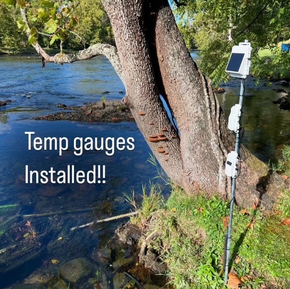
The BRGA installed temperature gauges in 6 locations on the Watauga and the South Holston. Lower, middle and upper. These gauges provide automatic data feeds on water temperature, which are important to trout health. They provide a reliable data source for the TVA and help build the relationship between the two organizations. The gauges cost $1,347 each. The BRGA and the OMTU added to the TTF donations to close the gap in total cost. The guages were installed before Helene, were taken down and reinstalled.
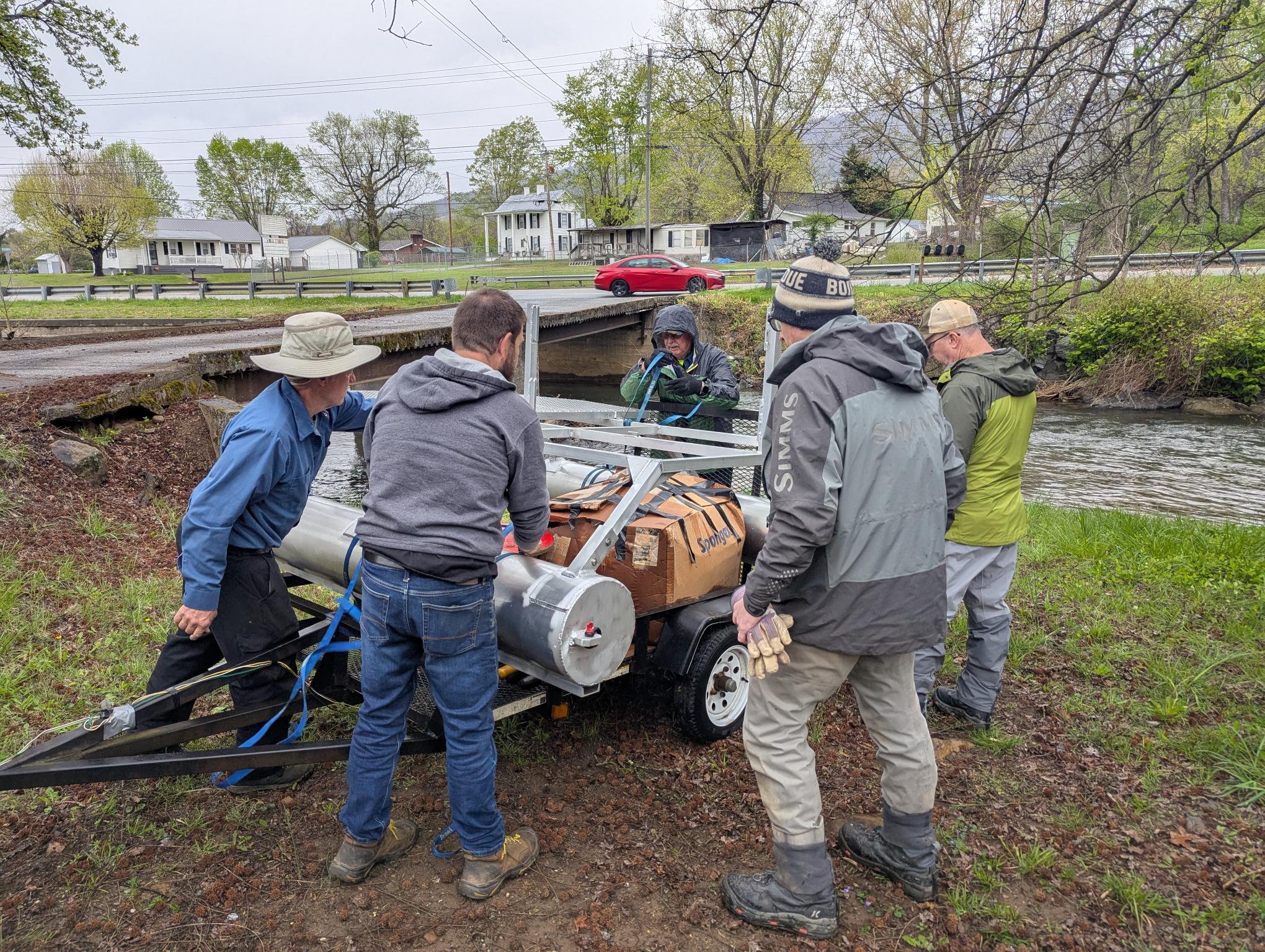
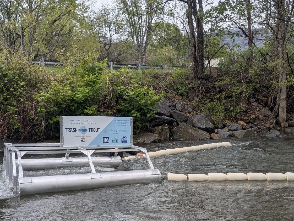
 In April, OMTU is planning to install a passive trash collector on Stoney Creek, one of the tributaries of the Watauga. These float and are about the size of a pontoon boat. There was a pre-existing one on the Buffalo Creek. They are able to measure the pounds of trash collected annually. The OMTU Chapter and TTF each contributed to the funding of the floating trash collector on Stoney Creek.
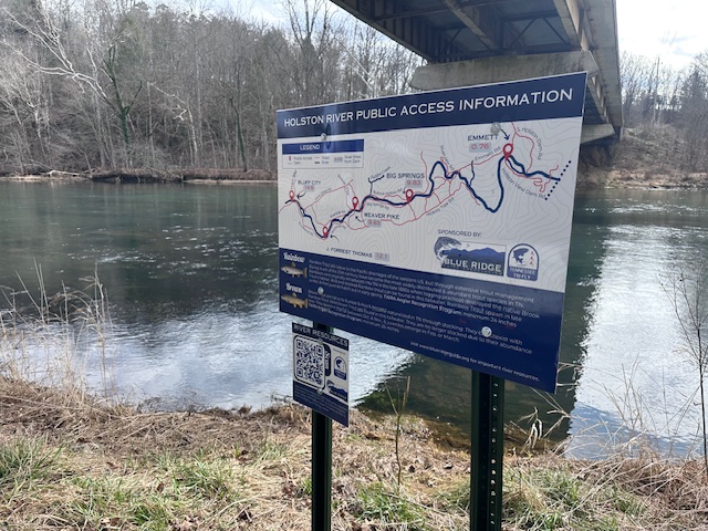
The Blue Ridge Guide Association is proud to announce the installation of permanent signage at 10 public access points along the South Holston River and Watauga River, made possible through a generous donation from Tennessee TRI-FLY.
Each sign clearly identifies the public access location and notes the river mile distance from the dam — critical information for anglers, boaters, and paddlers navigating these tailwaters. To further enhance safety and accessibility, the signage includes a QR code linking directly to BRGA’s newly developed online Resource Page.
This digital resource provides:
- TVA generation schedules
- River safety information
- Updated river maps
- CFS flow rates
- Approximate water arrival times for each river
By combining physical signage with dynamic online resources, this initiative helps ensure boaters, anglers, and paddlers have access to accurate, real-time safety information before and during their time on the water.
On Saturday, February 21st, two volunteer teams totaling eight individuals(and a really nice dog) installed the signage, contributing more than 50 volunteer hours. In total, 10 large signs and 10 small signs were installed across both rivers.
The project’s total cost exceeded $3,500 and included sign production, hardware, posts, equipmentrental, graphic design, and website development services. Thanks to Tennessee TRI-FLY’s leadership donation and the hard work of volunteers, this initiative significantly enhances public safety and river awareness for our entire community.
The Blue Ridge Guide Association is honored to partner with Tennessee Tri-Fly in strengthening river safety, supporting responsible recreation, and investing in the well-being of our fly fishing community.
Overmountain TU Chapter
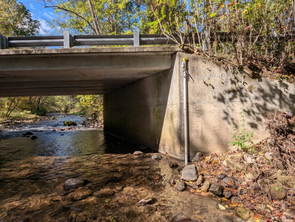
The Overmountain Chapter of Trout Unlimited installed cellular water level and temperature monitoring devices on three wild trout streams in northeast Tennessee. This initiative gathers critical data that can guide OMTU conservation efforts and ensure sustainable fishing practices in these waterways.
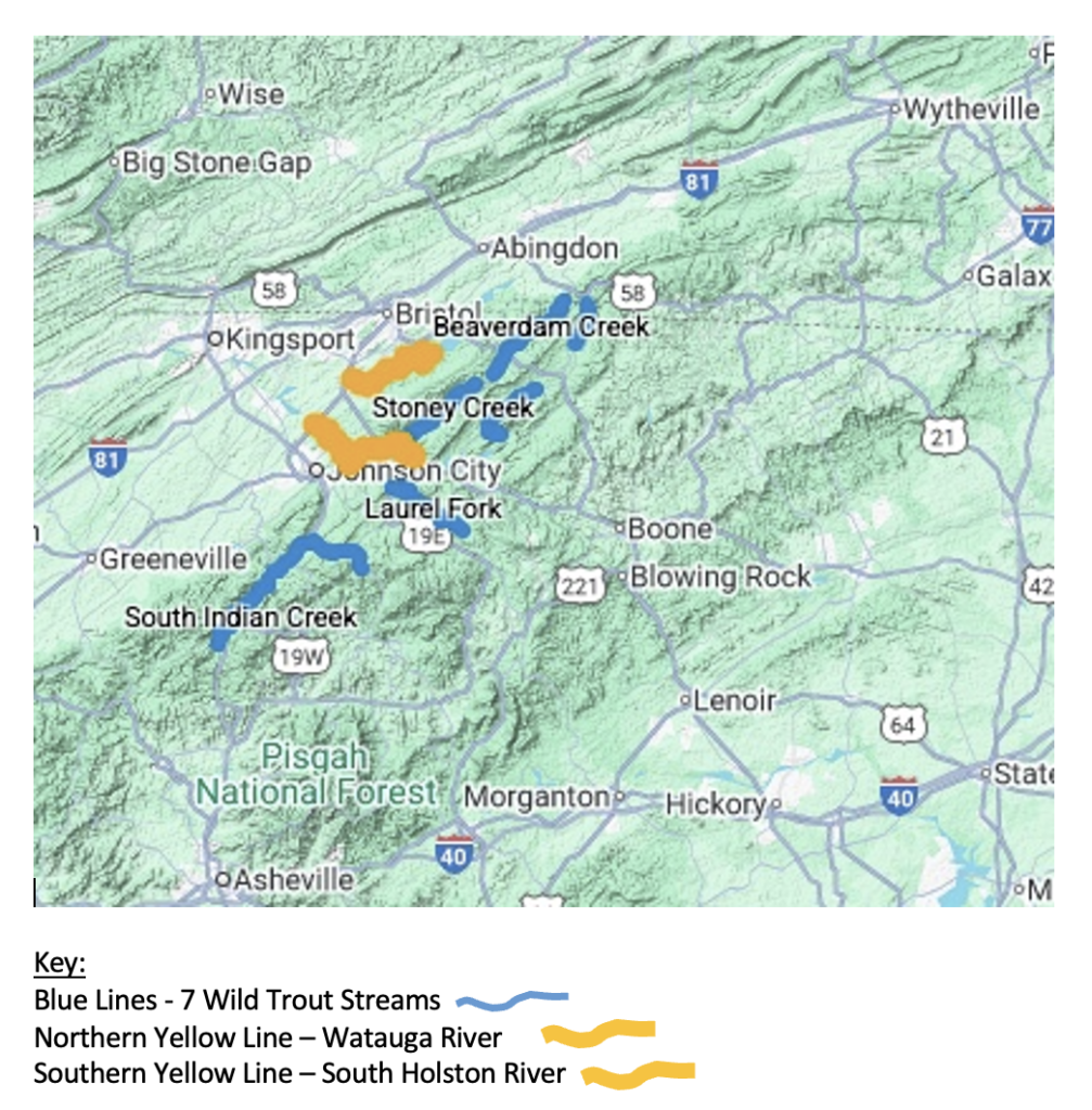
- Beaverdam Creek – Home to a wild brown trout population, this creek flows into the South Holston Reservoir.
- Doe Creek – Home to a wild rainbow trout population, this creek flows into the Watauga Reservoir.
- Laurel Fork – Home to a wild brown trout population, this creek flows into the Doe River and then into the Watauga River.
Each monitoring device sends hourly updates on both water temperature and water level directly to the OMTU website, allowing for real-time access to data. This data can also be pulled on demand from the database for a look at historical information.
The actual cost of the devices and installation was $6,432. Tennessee Tri-Fly contributed $3,000 towards this cost with the remainder funded by the Overmountain Chapter of Trout Unlimited.
![]()
2026
Overmountain TU Chapter
Project Title:
Phase II – Expansion of Temperature and Flow Monitoring Network on Wild Trout Streams in Northeast Tennessee
Executive Summary:
In 2025, the Overmountain Chapter of Trout Unlimited successfully installed three cellular water level and temperature monitoring devices on Beaverdam Creek, Doe Creek, and Laurel Fork. These devices are now providing hourly environmental data to anglers, biologists, land managers, and the public — helping reduce thermal stress on wild trout populations, guiding conservation work, and building a valuable long-term data record.
For 2026, we respectfully request support to expand this monitoring network by installing three additional cellular monitoring units on the following priority wild trout streams:
- Stoney Creek (Carter County) – Home to wild brown, rainbow, and brook trout. It's a tributary to the Watauga River.
- Laurel Creek (Johnson County) – Home to wild rainbow and brown trout. It's a tributary to the South Holsten Lake.
- North Indian Creek (Unicoi County) – Home to wild rainbow, brown, and brook trout. It's a tributary to the Nolichucky.
- South Indian Creek (Unicoi County) – Home to wild rainbow trout. It's a tributary to the Nolichucky.
Unfortunately, many of the streams have experienced irregular or declining population trends over the last decade, driven by warming waters, altered flow patterns, habitat loss, and climatic variability. By expanding our real-time monitoring network, we will strengthen regional trout conservation, promote responsible angling, and generate long-term scientific data that will guide future restoration efforts.
Background and Need:
The 2025 monitoring project demonstrated clear and immediate benefits:
- Anglers actively used real-time temperature data to avoid fishing during unsafe thermal conditions.
- Our chapter used hourly flow data to make informed decisions on cleanups, volunteer workdays, and youth events.
- Long-term data collection is now underway, providing insight into seasonal temperature trends, drought impacts, and stormwater dynamics.
However, the three streams monitored in 2025 represent only a portion of the region’s wild trout waters. Our chapter covers a large geographical area, and several additional streams— particularly Stoney Creek, Laurel Creek, North Indian Creek, and South Indian Creek —lack the same level of environmental monitoring despite holding important and sensitive trout populations. Expanding the network will create a region-wide baseline dataset and significantly enhance our ability to understand watershed health, respond to environmental threats, and engage the angling community in conservation stewardship.
Budget Overview:
- Water Temperature / Level Device Cost: $8,305 (total for 4 units)
- Ancillary Equipment and Mounting
- Hardware: $300
- Total Cost: $8,605
- Installation & Web Integration: Provided by Overmountain TU volunteer labor
Each angler with contribute $500 to the OTMU for a total $7,000. The OMTU pick up the difference using their own funds.
Timeline:
- March 2026: Finalize site selection and obtain landowner permissions
- April 2026: Device delivery (3–4 week lead time)
- May–July 2026: Installation, testing, and dashboard updates
- July 2026 onward: Real-time public data available